
Nagpur advocates for actions to conserve and enhance biodiversity
June 14, 2021
Small cities and towns struggle to finance climate action, but better data can help
July 5, 2021The Indian cities of Thane and Nagpur have completed their Climate Risk and Vulnerability Assessments (CRVA), with the support of the Urban-LEDS II project. The CRVAs include an analysis of various climate hazards and risks, preparedness and consideration of such risks, various services potentially impacted, and identification of vulnerable population and specific areas for prioritized actions. Based on their GHG emission inventories and CRVAs, Climate Resilience Action Plans are being developed for both cities to propose sector-wise strategies promoting low emission development and addressing climate-related vulnerabilities.
Given the ongoing COVID-19 pandemic, one-to-one dialogues were held with local experts, city officials and relevant stakeholders in both cities to inform the preparation of the CRVAs.
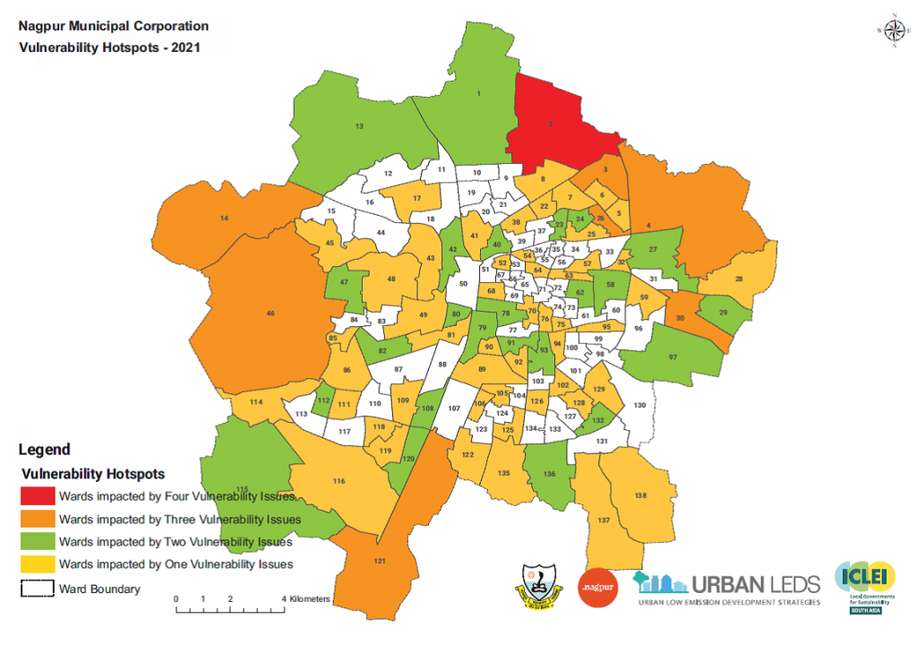
Highlights of Nagpur’s CRVA
Heat waves, encountered especially due to high temperature in Nagpur’s extreme summers, and urban heat island effect due to the city’s decreasing green cover and biodiversity loss along with changing rainfall patterns have been identified as key climate risks for Nagpur. Impacts of climate risks such as rising temperature and high intensity short duration rainfall have been analyzed in conjunction with infrastructure and provision of urban services across water supply, solid waste management, storm water drainage, wastewater collection and treatment, health and biodiversity.
Inputs received from stakeholders have been reinforced through literature research and collating data from various departments on water logging locations, traffic congestion areas, vulnerable population (such as slum areas). Vulnerabilities have been mapped through satellite imagery available for Nagpur’s green cover, overall land use pattern, and land surface temperature profile. Superimposed maps have been subsequently prepared to identify specific administrative wards (zones) that are vulnerable to climate risks. Adaptive capacities of urban services in terms of technology, finance, and governance were scrutinized in linkage with climate risks, to inform identification of suitable strategies and policy interventions.
Highlights of Thane’s CRVA
Key climate change risks identified for Thane include change in precipitation and increase in short duration high intensity rainfall events, change in temperature with an increase in average temperature (including occasional heat waves), and lastly sea level rise due to the city’s close proximity to the Ulhas River estuary and the Thane Creek. The potential impacts of these identified climate risks on basic municipal services such as water supply, storm water management, sewage treatment, solid waste management, transport, health, biodiversity, green cover and water bodies have been assessed.
Thane’s CRVA is equipped with vulnerability maps depicting locations vulnerable to rise in temperature, increase in short duration-high intensity rainfall, and sea level rise. These maps represent climate risks with allied issues such as land use and land cover, green cover, surface temperature, low lying and water logged areas, and areas prone to flooding from sea level rise. With air pollution highlighted as a major health hazard by city officials, the CRVA report includes maps showing concentrations of Respirable Particulate Matter (RSPM), SO2, NOx and overall Air Quality Index based on data from three air quality monitoring stations in the city. Traffic congestion points and areas housing urban poor population have also been mapped in consideration with the climate risks. For prioritizing actions, wards and locations vulnerable to various climate risks are identified to help the city administration to undertake targeted action for enhancing the city’s climate resilience.
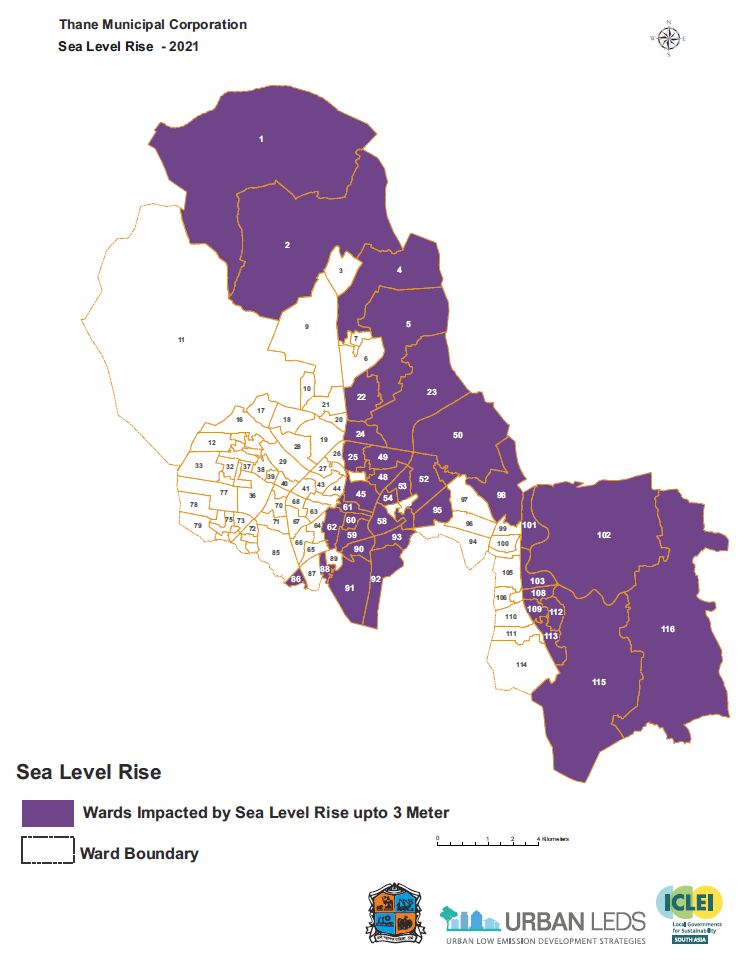
Administrative zones impacted by sea level rise mapped for Thane city. Prepared by ICLEI SA